Early Adopter

Applied Research Topic
Potential Applications ► Aquaculture site selection tool for Gulf of Maine
Description
In the last 9 years, Eastern oyster production in Maine has increased 8-fold, the number of limited purpose aquaculture licenses has increased from ~20 to over 600, and mussel production has quadrupled over the same time period. Maine has 3,500 miles of tidal shoreline over 200 miles of coastline. Although Maine’s serpentine coastline essentially means there are many sites to match the right environment and species, most of the aforementioned aquaculture production still occurs in relatively few estuaries. The objective of our project is to provide relevant remote sensing imagery to existing and prospective aquaculturists along a highly distributed network of estuaries along Maine’s coast. Our PACE Early Adopter has three objectives: (1) successfully transfer processed images of species composition and phytoplankton functional types for nearshore Gulf of Maine to our site selection tool, (2) deploy an Imaging Flow CytoBot in a potential growing area just offshore of Casco Bay, Maine to compare with PACE products, and (3) develop relationships between LandSat OLI and PACE products for potential inshore extrapolation of PACE’s hyperspectral images.This work is supported by a National Sea Grant award NA18OAR4170330: New high-resolution satellite-derived water-quality data informs sustainable aquaculture development and NOAA Saltonstall Kennedy award # NA18NMF4270188: Optimizing production and products for scallop aquaculture.
Significance
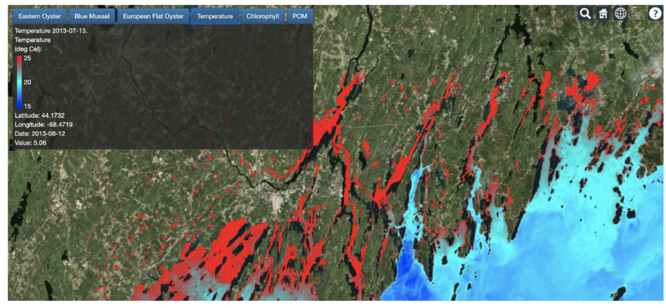
PACE imagery will be integrated with an aquaculture site selection tool. Growers can choose species and environmental conditions to optimize site selection. Upon choosing a site, a grower usually takes preliminary measurements and then the permitting process can take 1-2 years. Consequently, the initial site selection process is tremendously important to get right or a grower can be set back years. By choosing optimal sites with the best available information, our tool can save prospective growers money and time. PI Brady teaches a module in the Aquaculture in Shared Waters course (one of the largest training courses for prospective growers in the nation: 52 in the current class). The tools to link remote sensing imagery with production of new and emerging aquacultured industries, such as Japanese ‘ear-hung’ sea scallops and European oysters, are also in development.Why PACE
Our goals for the PACE Early Adopter program are two-fold: (1) to determine whether the procedure our team used to extrapolate relatively coarse remote sensing imagery in to nearshore waters by linking AVHRR to LandSat and Sentinel 2A/B will work for PACE products (phytoplankton functional types and species composition) and (2) to use existing PACE products to inform site selection in relatively offshore locations (e.g., sea scallops and blue mussels). Sea scallop aquaculture is a promising field of bivalve aquaculture due to our large sea scallop trade deficit and the size of the domestic market for cultured sea scallops. This species will be cultured in offshore waters due to their temperature preference. PACE resolution would be optimal for site selection tools for these species if we can relate phytoplankton size to feeding rates. As part of a leveraged USDA Aquaculture Experimental Station program, we will be deploying an Imaging Flow CytoBot (IFCB) in potential sea scallop growing areas that can be used to validate PACE products.End User(s)
Our end users change each year and with over 600 Limited Purpose Aquaculture License holders in the state, no one POC is appropriate at this time.SAT Partner(s)
Emmanuel BossPublications
Cold water aquaculture resilience, a review of the impact of likely scenarios in a climate change vulnerable ecological system. Bricknell, I.; Birkle, S.; Van Kirk, T. Hamlin, H.; Duffy, K.; Brawley, S.; Capistrant-Fossa, K.; Hugenard, K.; Byron, C.; Van Walsum, P.; Liu , Z.; Zhu , L. ; Johnston, T.; Grebe, G.; Taccardi, E.; Miller, M.; Preziosi, B.; Brady, D.; Bowden, T.; Quigley, C.; Moeykens, S. Reviews in Aquaculture. (Accepted).
Beard, K., Kimble, M., Yuan, J., Evans, K.S., Liu, W., Brady, D.C., Moore, S. (2020) A method for heterogeneous spatio-temporal data integration in support of marine aquaculture site selection. Journal of Marine Science and Engineering. 8 (2): 96-111. DOI: https://doi.org/10.3390/jmse8020096.
Adams, C.M., Mayer, L., Rawson, P., Brady, D.C., & Newell, C. (2019) Detrital protein contribution to oyster nutrition and growth in the Damariscotta estuary, Maine, USA. Aquaculture Environmental Interactions DOI: https://doi.org/10.3354/aei00330.
Johnson, T.R., Beard, K., Brady, D.C., Byron, C.J., Cleaver, C., Duffy, K., Keeney, N., Kimble, M., Miller, M., Moeykens, S., Teisl, M., van Walsum, G.P., Yuan, J. (2019) A social-ecological systems framework to guide marine aquaculture research. Sustainability 2019, 11, 2522; DOI: https://doi.org/10.3390/su11092522.
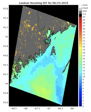
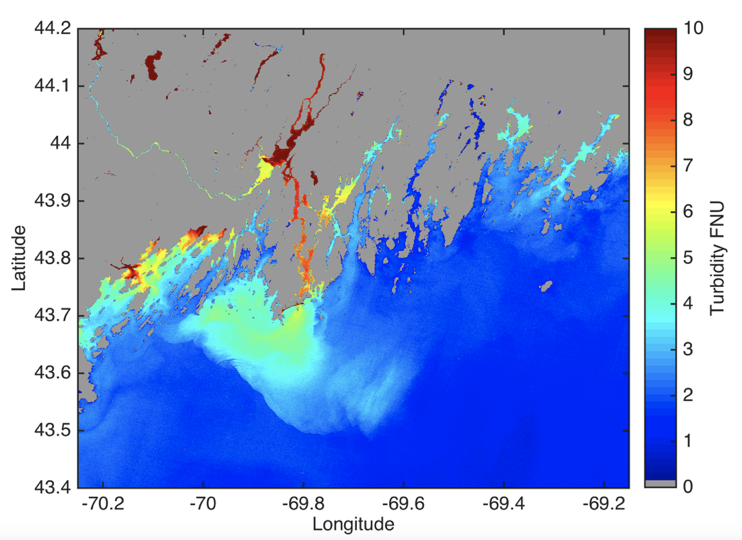
Snyder, J., Boss, E., Weatherbee, R., Thomas, A., Brady, D.C., and Newell, C. (2017) Oyster aquaculture site selection using Landsat 8-derived sea surface temperature, turbidity, and chlorophyll a. Frontiers in Marine Science 4(190), 1-11 DOI: https://doi.org/10.3389/fmars.2017.00190.