Early Adopter
Applied Research Topic
Ocean Colorimetry with PACE
Co-Is: Sherwin Ladner, US NRL Stennis Space Center; David Lewis, US NRL Stennis Space Center
Potential Applications ► Turbid waters monitoring and prediction for water resource management and US Navy operations planning; Coastal sediment plume tracking; Improve coastal numerical ocean models and coupled air-sea numerical models
Description
Dedicated polar-orbiting ocean color sensors (VIIRS, OLCI, MODIS) do not provide the temporal density available from a geostationary platform (with the present exception of GOCI). Visible-band data from meteorological sensors (such as ABI) on geostationary satellite platforms (GOES-R) lack the sensitivity and dynamic range normally attendant to dedicated ocean color radiometers. We propose to render the GOES-R data useful for coastal oceanographic applications via data convolution/merging techniques by combining GOES-R scenes with data from dedicated ocean-viewing radiometers. However, the existing ocean color sensors are multispectral, and accurate colorimetry computation requires a hyperspectral dataset. In order to establish true color as a reference, we need a hyperspectral sensor. PACE data are ideally suited for this purpose. In this PACE early adopter proposal, we intend to build upon that earlier work to (1) develop ocean color products based on these techniques using PACE datasets as a true color reference; and (2) demonstrate how these products may be used as a data source to constrain and inform coastal numerical ocean models and coupled air-sea numerical models.Significance
Environmental decision support is a broad umbrella of activity that encompasses both civilian and military applications. Evaluating the high spatial and temporal resolution movements of turbidity plumes in coastal areas is important to the US Navy. For example, since certain deployable assets utilize LIDAR or Laser Line-type Electro-Optical technologies, prediction of turbid conditions is useful for operations planning. More generally, resource managers and coastal researchers will find high-temporal resolution datasets that provide the synoptic spatial coverage of remote sensing images very useful for a wide variety of purposes. Monitoring river outflows or turbidity plume expansion from estuaries, for example, has a wide interest for many resource management purposes, such as protecting oyster fisheries and even red tide (harmful algal bloom) prediction and monitoring.Why PACE
PACE synthetic and PACE genuine datasets will be used to establish colorimetric reference points as a means to “colorize” / enhance GOES-R and other geostationary satellite data. The basis of colorimetry is a hyperspectral radiant power distribution. Short of that, there is inherent error in the colorimetric computation. In order to make ocean colorimetry reproducible and therefore useful, a hyperspectral standard is required. Without PACE, the hyperspectral standards would be limited to numerical simulation of hydrological optics (e.g., HYDROLIGHT) and spatially restricted/limited datasets from hand-held or ship-deployed hyperspectral instruments.End User(s)
Naval Research Laboratory- Ocean Modeling and Prediction BranchSAT Partner(s)
Michael TwardowskiPublications
Jolliff, J.K.; Lewis, D.M.; Ladner, S.; Crout, L.R. (2019) Observing the Ocean Submesoscale with Enhanced-Color GOES-ABI Visible Band Data. Sensors, 19, DOI: https://doi.org/10.3390/s19183900.
Miller, S. D., C. C. Schmidt, T. J. Schmit, and D. W. Hillger (2011), A case for natural colour imagery from geostationary satellites, and an approximation for the GOES-R ABI, International Journal of Remote Sensing, 33(13), DOI: https://doi.org/10.1080/01431161.2011.637529.
Vanhellemont, Q., G. Neukermans, and K. Ruddick (2014), Synergy between polar-orbiting and geostationary sensors: Remote sensing of the ocean at high spatial and high temporal resolution, Remote Sensing of Environment, 146, 49-62, DOI: https://doi.org/10.1016/j.rse.2013.03.035.
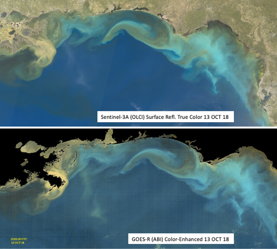
Satellite imagery from the northern Gulf of Mexico on 13-Oct-18. Top: Surface reflectance true color from Sentinel-3’s Ocean and Land Colour Instrument (OLCI). Bottom: Color-enhanced image from the GEOS-R Advanced Baseline Imager (ABI).
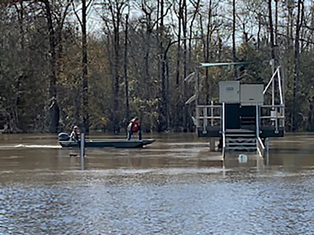
Scientists use a boat to collect turbidity data from an in-water station.

Turbid water conditions as seen from a fixed observation station.