Early Adopter
Earth Observation Research Group, Council for Scientific and Industrial Research (CSIR) | Website
Applied Research Topic
Potential Applications ► Fisheries and aquaculture decision support tool for the South African coast
Description
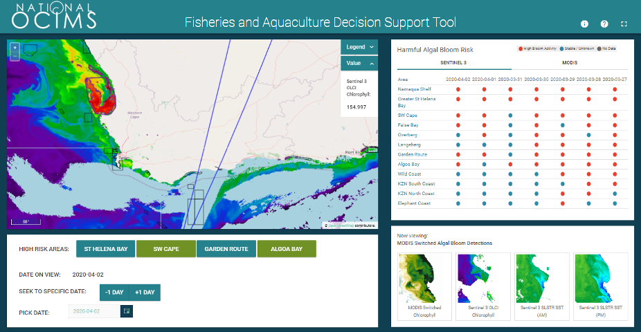
The South African west and south coasts suffer from the frequent occurrence of Harmful Algal Blooms (HABs). These blooms can have considerable negative impacts on commercial marine industries including aquaculture operations, in addition to local marine ecosystems and communities. The South African marine aquaculture sector centers around mussel Mytilus galloprovincialis, Pacific oyster Crassostrea gigs, and abalone Haliotis mid farming, with most facilities situated along the west coast in close proximity to the productive Benguela current upwelling system. HAB impacts come about through either the toxicity (to humans and animals) of some bloom species (e.g. red tides), or collapse of high biomass blooms through nutrient exhaustion, leading in extreme cases to hypoxia and dramatic mortalities of marine organisms.The National Oceans and Coastal Information Management System (OCIMS) project aims to develop a locally relevant and globally cognizant technological solution that supports the ecological conservation and economic potential of South Africa's oceans and coasts through information and decision-support for effective governance of South Africa's oceans and coasts. The project features a number of Decision Support Tools (DeST), the most relevant of which are the Fisheries and Aquaculture DeST, Water Quality DeST, and Marine Predator DeST.
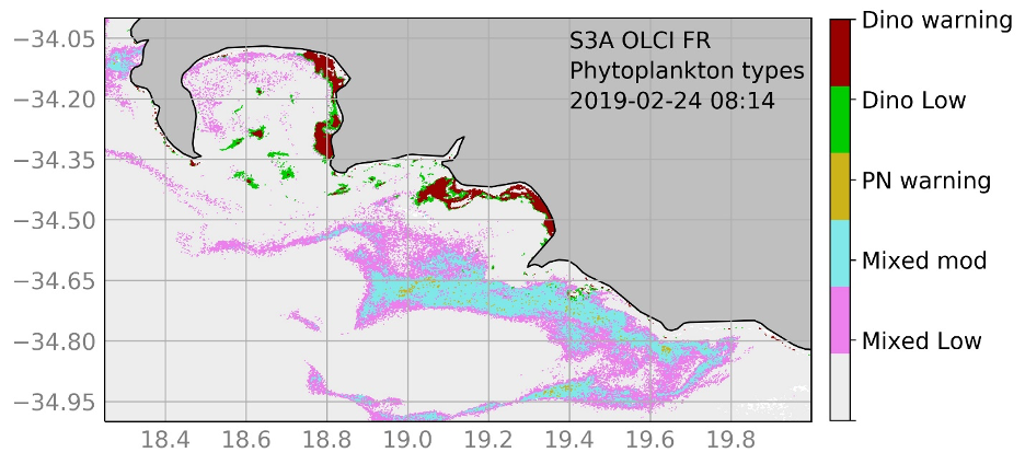
Our PACE Early Adopter project has two components: 1) Coastal Harmful Algal Bloom (HAB) research (Application Area: Water quality and resources, ecological forecasting), and 2) Southern Ocean Phytoplankton Functional Type identification (Application Area: Climate, and Ecological Forecasting). The two components both employ the same hyperspectral phytoplankton inherent optical properties (IOP) model which can be applied to satellite radiometry for products facilitating the identification and evaluation of HAB threats, examine sensitivity to detailed size-based phytoplankton functional type (PFT) discrimination, and inform on the limits of phytoplankton identification from satellite radiometry.
Significance
Operational HAB detection and monitoring networks inform both public health and industry decision-making (e.g. aquaculture and SWRO desalination). Supporting small scale commercial and subsistence fishing is a new area of expansion - identifying productive areas for fishing, as well as potential negative health impacts of harmful species. Southern Ocean PFT research has massive climate research implications and this work feeds into global work on carbon cycling by the oceanographic research community. Work towards the identification of fishing zones and indicators of ecosystem health in the S. Ocean island regions is also a potential area of application.Why PACE
PACE is uniquely hyperspectral. We are interested in: 1) identifying precise radiometric signals (in terms of wavelength) that can inform on size-based PFT identification; and 2) assessing the limits of phytoplankton detection in terms of biomass and strength of phytoplankton signal. PACE is uniquely positioned to provide the information needed for both accurate atmospheric correction and detailed investigation of the narrow spectral signals generated by phytoplankton backscatter, which our research has indicated are potentially important for PFT identification. Phytoplankton type, size, and biomass information derived from PACE data will be integrated and displayed as new products on the relevant OCIMS decision support tools and distributed as part of regional HAB bulletins and warnings.End User(s)
Aquaculture farms on West and Southern Cape Coasts, local municipalities, desalination plants, recreational and subsistence fisherpeople via the National Oceans and Coastal Information Management System (OCIMS) for South Africa and Abalone mobile-app project.Council for Scientific and Industrial Research (CSIR) and international Southern Ocean Carbon & Climate Observatory (SOCCO) partners
SAT Partner(s)
Peter Gaube and Alison ChasePublications
Smith, Marié E., L. Robertson Lain, and S. Bernard. (2018) An optimized chlorophyll a switching algorithm for MERIS and OLCI in phytoplankton-dominated waters. Remote Sensing of Environment. 215: 217-227. DOI: https://doi.org/10.1016/j.rse.2018.06.002.
Smith, Marié E., and Stewart Bernard. (2020) Satellite Ocean Color Based Harmful Algal Bloom Indicators for Aquaculture Decision Support in the Southern Benguela. Frontiers in Marine Science 7: 61. DOI: https://doi.org/10.3389/fmars.2020.00061.
Lain, Lisl Robertson, and Stewart Bernard. (2018) The fundamental contribution of phytoplankton spectral scattering to ocean colour: implications for satellite detection of phytoplankton community structure. Applied Sciences 8.12: 2681. DOI: https://doi.org/10.3390/app8122681.