People
Science Meeting Presentations (9)
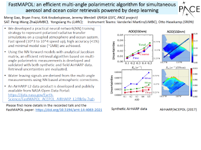
FastMAPOL: An Efficient Multi-angle Polarimetric Algorithm for Simultaneous Aerosol and Ocean Color Retrievals Powered by Deep Learning
Gao, M. (06-Oct-21) 
Land and Ocean Versions of ATREM Codes for Processing Hyperspectral Imaging Data Sets
Gao, B-C. and Li, R-R. (16-Jan-18) 
PACE Atmospheric Correction Focusing on Adaptation of NASA’s Heritage Algorithm
Franz, B., Ibrahim, A., Ahmad, Z., Gao, B-C., and Zhai, P. (16-Jan-18) 
Land and Ocean Versions of ATREM Codes for Processing AVIRIS-Simulated PACE Proxy Data
Gao, B-C. and Li, R-R. (17-Jan-17). Click here to view this presentation with audio. 
PACE Atmospheric Correction Focusing on Adaptation of NASA’s Heritage Algorithm
Franz, B., Ibrahim, A., Ahmad, Z., Healy, R., and Gao, B-C. (17-Jan-17) 
PACE Science Team: Atmospheric Correction over Bright Water Targets with Non-negligible Radiances in the Near Infrared
Dierssen, H., Randolph, K., Garaba, S., Zhai, P., and Gao, B-C. (17-Jan-17) 
Hyperspectral and Multispectral Atmospheric Correction Algorithms for Supporting the NASA PACE Mission
Gao, B-C. and Li, R-R. (21-Jan-16) 
Implementing Heritage AC Algorighm for Hyperspectral Rrs Retrieval
Ibraham, A., Franz, B., Ahmad, Z., Healy, R., and Gao, B-C. (21-Jan-16) 
Hyperspectral and Multispectral Atmospheric Correction Algorithms Supporting the NASA PACE Mission
Gao, B-C. (14-Jan-15) Publications (34)
Remer, L.A., Davis, A.B., Mattoo, S., Levy, R.C., Kalashnikova, O.V., Coddington, O., Chowdhary, J., Knobelspiesse, K., Xu, X., Ahmad, Z., Boss, E., Cairns, B., Dierssen, H.M., Diner, D.J., Franz, B., Frouin, R., Gao, B-C., Ibrahim, A., Martins, J.V., Omar, A.H., Torres, O., Xu, F., and Zhai, P-W. (2019). Retrieving Aerosol Characteristics From the PACE Mission, Part 1: Ocean Color Instrument, Front. Earth Sci., 7, 152, doi: 10.3389/feart.2019.00152.
Remer, L.A., Knobelspiesse, K., Zhai, P-W., Xu, F., Kalashnikova, O.V., Chowdhary, J., Hasekamp, O., Dubovik, O., Wu, L., Ahmad, Z., Boss, E., Cairns, B., Coddington, O., Davis, A.B., Dierssen, H.M., Diner, D.J., Franz, B., Frouin, R., Gao, B-C., Ibrahim, A., Levy, R.C., Martins, J.V., Omar, A.H., and Torres, Om (2019). Retrieving Aerosol Characteristics From the PACE Mission, Part 2: Multi-Angle and Polarimetry, Front. Earth Sci., 7, 94, doi: 10.3389/fenvs.2019.00094.
Frouin, R.J., Franz, B.A., Ibrahim, A., Knobelspiesse, K., Ahmad, Z., Cairns, B., Chowdhary, J., Dierssen, H.M., Tan, J., Dubovik, O., Huang, X., Davis, A.B., Kalashnikova, O., Thompson, D.R., Remer, L.A., Boss, E., Coddington, O., Deschamps, P-Y., Gao, B-C., Gross, L., Hasekamp, O., Omar, A., Pelletier, B., Ramon, D., Steinmetz, F., and Zhai, P-W. (2019). Atmospheric Correction of Satellite Ocean-Color Imagery During the PACE Era, Front. Earth Sci., 7, 145, doi: 10.3389/feart.2019.00145.
Ibrahim, A., Franz, B., Ahmad, Z., Healy, R., Knobelspiesse, K., Gao, B.-C., Proctor, C., and Zhai, P.-W. (2017). Atmospheric Correction for Hyperspectral Ocean Color Retrieval with Application to the Hyperspectral Imager for the Coastal Ocean (HICO), Rem. Sens. Envir., 204, 60-75, doi: 10.1016/j.rse.2017.10.041.
Dierssen, H.M., McManus, G., Chlus, A., Qiu, D., Gao, B.-C., and Lin, S. (2015). Space Station Image Captures a Red Tide Ciliate Bloom at High Spectral and Spatial Resolution, Proc. National Acad. Sci., 112 (48), 14783-14787.
Thompson, D.R., Gao, B.-C., Green, R.O., Roberts, D.A., Dennison, P.E., and Lundeen, S.R. (2015). Atmospheric Correction for Global Mapping Spectroscopy: ATREM Advances for the Hyspiri Preparatory Campaign, Remote Sens. Environ., 167, 64-77, doi: 10.1016/j.rse.2015.02.010.
Thompson, D.R., Seidel, F.C, Gao, B.-C., Gierach, M.M., Green, R.O., Kudela, R.M., and Mouroulis, P. (2015). Optimizing Irradiance Estimates for Coastal and Inland Water Imaging Spectroscopy, Geophys. Res. Lett., 42(10), 4116-4123, doi: 10.1002/2015GL063287.
Mouroulis, P., Gorp, B., Green, R., Dierssen, H., Wilson, D., Eastwood, M., Boardman, J., Gao, B., Cohen, C., Franklin, B., Loya, F., Lundeen, S., Mazer, A., McCubbin, I., Randall, D., Richardson, B., Rodriguez, J., Sarture, C., Urquiza, E., Vargas, R., White, V., and Yee, K. (2014). The Portable Remote Imaging Spectrometer (PRISM) Coastal Ocean Sensor: Characteristics and First Flight Results, Appl. Opt., 53(7), 1363-1380, doi: 10.1364/AO.53.001363.
Gao, B.-C. and Liu, M. (2013). A Fast Smoothing Algorithm for Post-Processing of Surface Reflectance Spectra Retrieved from Airborne Imaging Spectrometer Data, Sensors, 13(10), 13879-13891, doi: 10.3390/s131013879.
Gao, B.-C. and Chen, W. (2012). Multispectral Decomposition for the Removal of Out-Of-Band Effects of Visible/Infrared Imaging Radiometer Suite Visible and Near-Infrared Bands, Appl Opt., 51(18), 4078-4086, doi: 10.1364/AO.51.004078.
Gao, B.-C., Li, R.-R., Lucke, R.L., Davis, C.O., Bevilacqua, R.M., Korwan, D.R., Montes, M.J., Bowles, J.H., and Corson, M.R. (2012). Vicarious Calibrations of HICO Data Acquired from the International Space Station, Appl. Opt., 51(14), 2559-2567, doi: 10.1364/AO.51.002559.
Gao, B.-C. and Li, R.R. (2012). Removal of Thin Cirrus Scattering Effects for Remote Sensing of Ocean Color from Space, IEEE Geosci. Remote S., 9(5), 972-976, doi: 10.1109/LGRS.2012.2187876.
Li, R.-R., Lucke, R., Korwan, D., and Gao, B.-C. (2011). A Technique for Removing Second-Order Light Effects from Hyperspectral Imaging Data, IEEE Geosci. Remote S., 50(3), 824-830, doi: 10.1109/TGRS.2011.2163161.
Gitelson, A.A., Gao, B.-C., Li, R.-R., Berdnikov, S., and Saprygin, V. (2011). Estimation of Chlorophyll-a Concentration in Productive Turbid Waters Using a Hyperspectral Imager for the Coastal Ocean - The Azov Sea Case Study, Environ. Res. Lett., 6(2), 024023, doi: 10.1088/1748-9326/6/2/024023.
Lee, J., Yang, P., Dessler, A.E., Gao, B.-C., and Platnick, S. (2009). Distribution and Radiative Forcing of Tropical Thin Cirrus Clouds, J. Atmos. Sci., 66(12), 3721-3731, doi: 10.1175/2009JAS3183.1.
Gao, B.-C., Montes, M.J., Davis, C.O., and Goetz, A.F.H. (2009). Atmospheric Correction Algorithms for Hyperspectral Remote Sensing Data of Land and Ocean, Remote Sens. Environ., 113(1), S17-S24, doi: 10.1016/j.rse.2007.12.015.
Meyer, K., Platnick, S., Yang, P., and Gao, B.-C. (2009). Cirrus Cloud Optical Thickness from Reflectance Measurements in the MODIS 1.38 µm Channel, AIP Conf. Proc., 1100, 404, doi: 10.1063/1.3117005.
Meyer, K., Yang, P., and Gao, B.-C. (2007). Tropical Ice Cloud Optical Depth, Ice Water Path, and Frequency Fields Inferred from the MODIS Level-3 Data, Atmos. Res., 85(2), 171-182, doi: 10.1016/j.atmosres.2006.09.009.
Gao, B.-C., Montes, M.J., Li, R.-R., Dierssen, H.M., and Davis, C.O. (2007). An Atmospheric Correction Algorithm for Remote Sensing of Bright Coastal Waters Using MODIS Land and Ocean Channels in the Solar Spectral Region, IEEE Geosci. Remote S., 45(6), 1835-1843, doi: 10.1109/TGRS.2007.895949.
Gao, B.-C., Montes, M.J., and Davis, C.O. (2004). Refinement of Wavelength Calibrations of Hyperspectral Imaging Data Using a Spectrum-Matching Technique, Remote Sens. Environ., 90(4), 424-433, doi: 10.1016/j.rse.2003.09.002.
Meyer, K., Yang, P., and Gao, B.-C. (2004). Optical Thickness of Tropical Cirrus Clouds Derived from the MODIS 0.66 and 1.375-µm Channels, IEEE Geosci. Remote S., 42(4), 833-841, doi: 10.1109/TGRS.2003.818939.
Gao, B.-C. and Kaufman, Y.J. (2003). Water Vapor Retrievals Using Moderate Resolution Imaging Spectrometer (MODIS) Near-IR Channels, J. Geophys. Res., 108(D13), 4389-4398, doi: 10.1029/2002JD003023.
Li, R.-R., Kaufman, Y.J., Gao, B.-C., and Davis, C.O. (2003). Remote Sensing of Suspended Sediments and Shallow Coastal Waters, IEEE Geosci. Remote S., 41(3), 559-566, doi: 10.1109/TGRS.2003.810227.
King, M.D., Menzel, W.P., Kaufman, Y.J., Tanré, D., Gao, B.-C., Platnick, S., Ackerman, S.A., Remer, L.A., Pincus, R., and Hubanks, P.A. (2003). Cloud and Aerosol Properties, Precipitable Water, and Profiles of Temperature and Water Vapor from MODIS, IEEE Geosci. Remote S., 41(2), 442-458, doi: 10.1109/TGRS.2002.808226.
Gao, B.-C., Kaufman, Y.J., Tanré, D., and Li, R.-R. (2002). Distinguishing Tropospheric Aerosols from Thin Cirrus Clouds for Improved Aerosol Retrievals Using the Ratio of 1.38-µm and 1.24-µm Channels, Geophys. Res. Lett., 29(18), 1890, doi: 10.1029/2002GL015475.
Gao, B.-C., Yang, P., Han, W., Li, R.-R., and Wiscombe, W.J. (2002). An Algorithm Using Visible and 1.38-µm Channels to Retrieve Cirrus Cloud Reflectances from Aircraft and Satellite Data, IEEE Geosci. Remote S., 40(8), 1659-1668, doi: 10.1109/TGRS.2002.802454.
Gao, B.-C. and Li, R.-R. (2000). Quantitative Improvement in the Estimates of NDVI Values from Remotely Sensed Data by Correcting Thin Cirrus Scattering Effects, Remote Sens. Env., 74(3), 494-502, doi: 10.1016/S0034-4257(00)00141-3.
Gao, B.-C., Montes, M.J., Ahmad, Z. and Davis, C.O. (2000). Atmospheric Correction Algorithm for Hyperspectral Remote Sensing of Ocean Color from Space, Appl. Opt., 39(6), 887-896, doi: 10.1364/AO.39.000887.
Gao, B.-C., Kaufman, Y.J., Han, W., and Wiscombe, W.J. (1998). Correction of Thin Cirrus Path Radiance in the 0.4 - 1.0 µm Spectral Region Using the Sensitive 1.375-µm Cirrus Detecting Channel, J. Geophys. Res., 103(D24), 32169-32176, doi: 10.1029/98JD02006.
Gao, B.-C. (1996). NDWI - A Normalized Difference Water Index for Remote Sensing of Vegetation Liquid Water from Space, Remote Sens. Environ., 58(3), 257-266, doi: 10.1016/S0034-4257(96)00067-3.
Gao, B.-C. and Kaufman, Y.J. (1995). Selection of the 1.375-µm MODIS Channel for Remote Sensing of Cirrus Clouds and Stratospheric Aerosols from Space, J. Atm. Sci., 52, 4231-4237, doi: 10.1175/1520-0469(1995)052<4231:SOTMCF>2.0.CO;2.
Gao, B.-C., Heidebrecht, K.H.,and Goetz, A.F.H. (1993). Derivation of Scaled Surface Reflectances from AVIRIS Data, Remote Sens. Environ., 44(2-3), 165-178, doi: 10.1016/0034-4257(93)90014-O.
Gao, B.-C., Goetz, A.F.H., and Wiscombe, W.J. (1993). Cirrus Cloud Detection from Airborne Imaging Spectrometer Data Using the 1.38 µm Water Vapor Band, Geophys. Res. Lett., 20(4), 301-304, doi: 10.1029/93GL00106.
Gao, B.-C. and Goetz, A.F.H. (1990). Column Atmospheric Water Vapor and Vegetation Liquid Water Retrievals from Airborne Imaging Spectrometer Data, J. Geophys. Res., 95(D4), 3549-3564, doi: 10.1029/JD095iD04p03549.