Early Adopter

Applied Research Topic
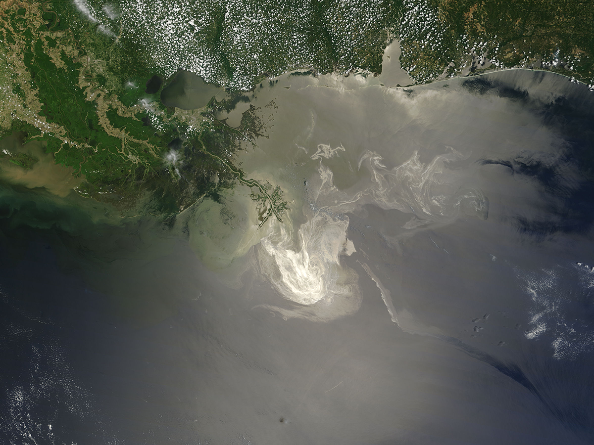
Potential Applications ► Disaster response and mitigation through detection and mapping of oil slicks and spills in the Gulf of Mexico
Description
Oil slicks on the ocean surface can result from natural seeps or oil spill accidents. They range from oil sheens, thick crude oil, oil-in-water emulsions, and water-in-oil emulsions. Detecting and differentiating these various types of oil slicks are difficult (although possible) with multi-band sensors, but the hyperspectral capacity of PACE should make it much easier for such purposes. During the Deepwater Horizon oil spill in the northern Gulf of Mexico in 2010, most of the remote sensing effort was focused on the oil spill’s surface footprint rather than surface oil type or oil volume. Significant progress has been made in understanding oil’s optical properties based on laboratory and airborne measurements, establishing a better understanding of how different oil types have different spectral shapes in the visible-NIR-SWIR spectral regions. Some of the oil-sensitive wavelengths, however, are not available on the existing multi-band sensors such as MODIS, VIIRS, or OLCI. The hyperspectral data collected by PACE will make these wavelengths available, thus improving oil spill remote sensing in a quantitative way and at sub-pixel scale. The latter is particularly useful as oil slicks are very patchy and heterogenous.Dr. Hu is also a member of the PACE Science and Applications Team (SAT). Read about a Science and Applications Team project that is related to his EA work.
Significance
Improved detection and differentiation of natural oil seeps or oil spill accidents can be used in disaster response, mitigation, and clean-up efforts.Why PACE
PACE has enough spectral bands in the 380 - 1000 nm spectral region and in the shortwave infrared spectral region (1.2 and 1.6 mm) to spectrally differentiate various types of oil slicks and quantify oil thickness. The hyperspectral capacity of PACE should make it possible to perform spectral diagnostics of their unique spectral features of oil in and on water.End User(s)
Oil companies (Exxon Mobil)Oil management agencies (BOEM, BSEE)
NOAA NRDA
NOAA CoastWatch
US Environmental Protection Agency
SAT Partner(s)
Matteo OttavianiPublications
Hu, C., L. Feng, J. Holmes, G. A. Swayze, I. Leifer, C. Melton, O. Garcia, I. MacDonald, M. Hess, F. Muller-Karger, G. Graettinger, and R. Green (2018). Remote sensing estimation of surface oil volume during the 2010 Deepwater Horizon oil blowout in the Gulf of Mexico: scaling up AVIRIS observations with MODIS measurements. J. Appl. Remote Sens. 12(2), 026008 (2018), DOI: https://doi.org/10.1117/1.JRS.12.026008.
Leifer, I., et al. (2012). State of the art satellite and airborne marine oil spill remote sensing: Application to the BP Deepwater Horizon oil spill. Remote Sens. Environ.,124:185–209. DOI: https://doi.org/10.1016/j.rse.2012.03.024.
Lu, Y., J. Shi, Y. Wen, C. Hu, Y. Zhou, S. Sun, M. Zhang, Z. Mao, and Y. Liu (2019). Optical interpretation of oil emulsions in the ocean–Part I: Laboratory measurements and proof-of-concept with AVIRIS observations. Remote Sens. Environ., 230, 111183, DOI: https://doi.org/10.1016/j.rse.2018.02.003.