Blog
PACE offers promising prospects for fishery management
Posted on Friday, September 5, 2025 at 12:40:00NASA's Plankton, Aerosol, Cloud, ocean Ecosystem mission, PACE, launched in February 2024 to study Earth’s ocean color, aerosols, and clouds. As researchers have started to use PACE data, they’ve identified many promising applications with PACE’s Ocean Color Instrument (OCI) to help fishing communities.
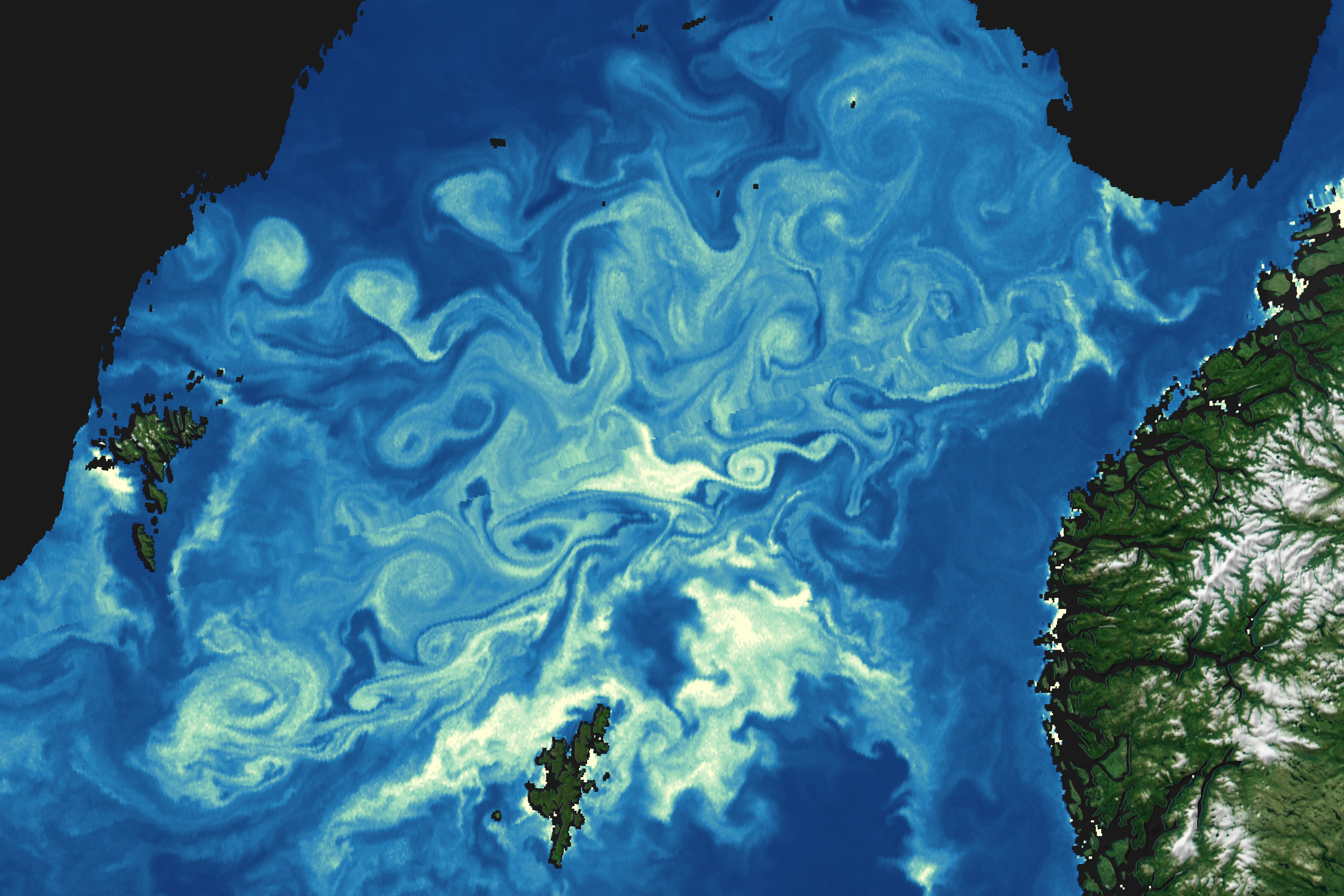
What makes PACE so special is its hyperspectral capabilities — it detects the full spectrum of visible wavelengths, plus a few more, to detect the colors reflecting from the ocean surface.

With other Earth-observing satellites, green regions might indicate phytoplankton presence and abundance, but PACE captures a more detailed fingerprint of ocean colors. This allows scientists to differentiate between communities. As the base of the food chain, phytoplankton have far-reaching impacts on the greater marine ecosystem.
More detailed information lets researchers better predict things such as where uncontrolled algal growth will pose a threat to fish, areas with more marine life, and where the preferred habitats for different species may be.
Monitoring Water Quality
Bingqing Liu, PACE Early Adopter and assistant professor and research scientist for the University of Louisiana in Lafayette, and her team are developing tools and water quality products using PACE data to monitor Gulf waters in real time. This supports more informed decision-making for management and protection of aquatic habitats, such as oyster beds and fish habitats. In a dynamic ecosystem like the Gulf Coast, understanding water quality changes can better prepare fisheries for future scenarios.
"I work on the linkage between phytoplankton and the fish. I look at how changes to the environment can impact how much and what kinds of phytoplankton there are. It can create a lot of harmful impacts on fisheries if the algae grow explosively," Liu said.
These episodes, called harmful algal blooms (HABs), can both release toxic compounds and deplete oxygen in the water. Hyperspectral ocean color data from PACE is extremely valuable for determining when and where blooms occur and whether they are toxic — in waters that are muddied from many complex sources.
"We have large rivers that deliver a lot of sediments, nutrients, and dissolved organic matter into the river, into the coastal system," Liu said. "This makes it very challenging to derive useful information about phytoplankton."
Liu is currently working on a project using PACE data to assess the harmful impacts caused by algal blooms in the region. During these blooms, the algae suck oxygen from the water as they multiply, creating regions of very low oxygen concentration that can cause fish and shellfish to die from suffocation.
"We really need the information of how abundant the algae in the water is, which we can derive from PACE, to predict how extensive the low-oxygen-concentration zone is," Liu said.
Liu uses PACE data to monitor the current situation as well as predict future scenarios decades down the line. Scientists can make more accurate predictions by including more nuance by taking more species into account, since the wide breadth of PACE’s color data allows it to better differentiate between phytoplankton species.
"After looking forward to PACE for many years, now that we have PACE data in hand, it’s not just a word or project to me anymore — it’s like a dream come true," Liu said.
Finding Hot Spots
In West Melbourne, Florida, Matt Upton brings satellite-informed data to clients, including recreational and commercial fishing customers around the world. With his company, Roffer’s Ocean Fishing Forecasting Service, he helps clients find productive waters, areas full of marine life, and preferred habitats of target species.
From ocean color data, analysts can derive where and how much phytoplankton there is in the water. Different water color can also give clues to the kind of fish living there, since some prefer clearer blue waters and others murkier green waters.
"Species like marlin tend to be attracted more to the clear water, the blue water. And there's other species, like tuna or sailfish, they don't really care. You'll find them in greener water also," said Upton.
Upton added that with PACE data identifying different communities of ocean life such as concentrations of floating plants and algae called weedlines, algal blooms, and higher plankton concentrations, analysts can help customers target areas with more marine life and preferred habitats for certain fish species.
"There will be many different products or parameters out there developed from PACE data that will help pinpoint certain phytoplankton or other plankton species that will give a better indicator of where weed lines are located or where widespread Sargassum patches will be," Upton said. "There are fishermen that look for where weedlines are because they are habitats for Mahi and other fish too."
At the same time, PACE can give a more complete picture in areas dense with algae which are harder to fish in when the weeds are too thick. The applications are abundant, and Upton said he plans to explore more as PACE data continues to flow and produce different data sets.
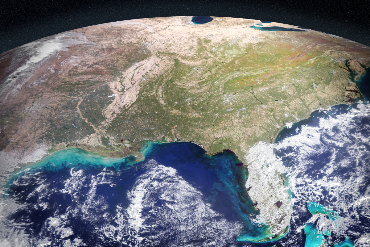 An image of the United States East Coast taken by OCI on October 21, 2024. (Credit: NASA/PACE)
The Bigger Picture: Ecosystem-based Management
Taking the whole picture into account is the National Oceanic and Atmospheric Administration’s National Marine Fisheries Service (NOAA Fisheries) in Silver Spring, Maryland, which helps manage the nation's marine resources and habitats. The agency is tasked with collecting data on fisheries and developing strategies to promote sustainable fisheries and healthy ecosystems.
"At a fundamental level, management of fisheries require an accurate and thorough quantification of living marine resources as well as their interactions with the marine ecosystem," said Ryan Vandermeulen, NOAA Fisheries satellite coordinator.
Vandermeulen helps to connect fishermen, scientists, and management councils with the wealth of information that satellite data provides. These groups can then use the scientific data to determine risks to fisheries and ecosystems that can potentially inform what caps to set on fishing.
There's a global push to evolve from species-by-species management of marine resources towards a more holistic approach that considers the whole ecosystem, Vandermeulen said. This is where ocean color satellites like PACE play an important role in characterizing phytoplankton, the very bottom of the marine food web. Since they serve as food for fish prey, higher plankton areas will tend to have more fish.
PACE data can also provide insights into the timing of phytoplankton blooms and growth, he said, which is important for fisheries management. "If your fish are adapted to having their larval hatch time coincide with peak phytoplankton bloom, and that bloom doesn't happen or it shifts, that's something that can translate into a decision down the road," Vandermeulen said. If we know that fewer fish will survive, management councils can lower fishing limits on that particular species to allow its population to rebound.
Vandermeulen is already looking for new ways to apply PACE's hyperspectral resolution. One project he is working on is detecting krill—which have a pinkish red hue—from space using PACE. This would open new doors because krill is a foundational species in many ecosystems, eaten by bigger marine species like salmon and whales.
"PACE has sparked a wave of curiosity and creativity in the ocean science community, and it’s thrilling to be swept up in that momentum," Vandermeulen said. "With the whole entirety of the world's ocean in hyperspectral detail at one's fingertips, the possibilities for discovery feel wide open."