Blog
NASA's PACE-OCI Provides Novel Detail in Tracking Nitrogen Dioxide and Ozone
Posted on Tuesday, March 17, 2026 at 12:00:00A New Window on Air Quality
Launched in February 2024, the Ocean Color Instrument (OCI) aboard NASA's PACE satellite was designed to advance space-based monitoring of our ocean and atmosphere by innovating how particles in the air (aerosols), clouds, and ocean ecosystems are observed. Researchers have discovered that OCI can also measure the vertical column density of nitrogen dioxide (NO2) and ozone (O3) with unprecedented spatial detail of about 1.2 kilometers (~0.75 miles x 0.75 miles) per pixel. Other satellites are specifically designed to detect these trace gases but do so at coarser resolution, typically around 5 kilometers per pixel.
NO₂ and O3 are critical players in air quality that contribute to smog and respiratory problems. NO₂ is emitted from anthropogenic sources such as vehicle exhaust, power plants, and industrial facilities, as well as from natural sources including biomass burning and soil/vegetation emissions. O3 is also emitted by anthropogenic sources plus it can form in the atmosphere through photochemical reactions involving NOx (NO and NO₂), volatile organic compounds (VOCs), and sunlight. Improving our ability to identify their sources and spatial distributions can enhance air quality monitoring and support more atmospheric modeling efforts.
Enabled by Machine Learning and NASA TROPOMI Satellite Data
Here's where it gets clever: OCI wasn't specifically designed to measure NO2 or O3, for this purpose it has relatively coarse spectral resolution compared to dedicated trace gas monitoring sensors. Researchers used machine learning, training a neural network to recognize patterns in OCI's hyperspectral data by comparing it with high-quality measurements from the trace gas monitoring TROPOMI satellite instrument. This approach is computationally efficient and doesn't require detailed prior information about surface properties, aerosols, or atmospheric profiles that traditional methods depend on.
The technique essentially taught PACE to "see" air pollution by learning from a trusted standard, and it works remarkably well across different geographic regions—from Los Angeles traffic to Saudi Arabian industrial zones to Midwestern power plants (Fasnacht et al. 2025).
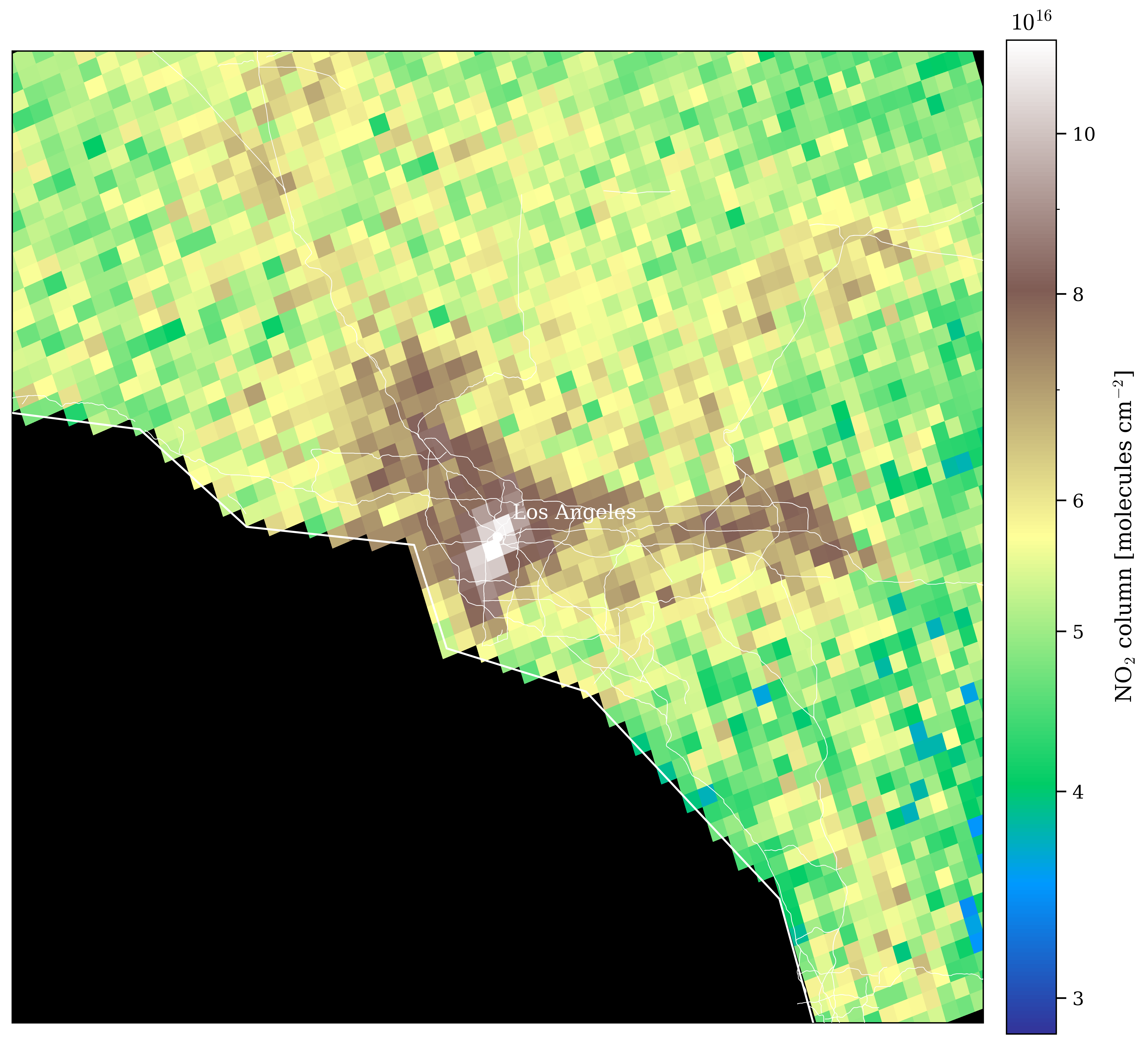
NO₂ in finer detail: PACE OCI compared with TROPOMI
Sentinel-5P TROPOMI NO2 Data
PACE OCI NO2 Data
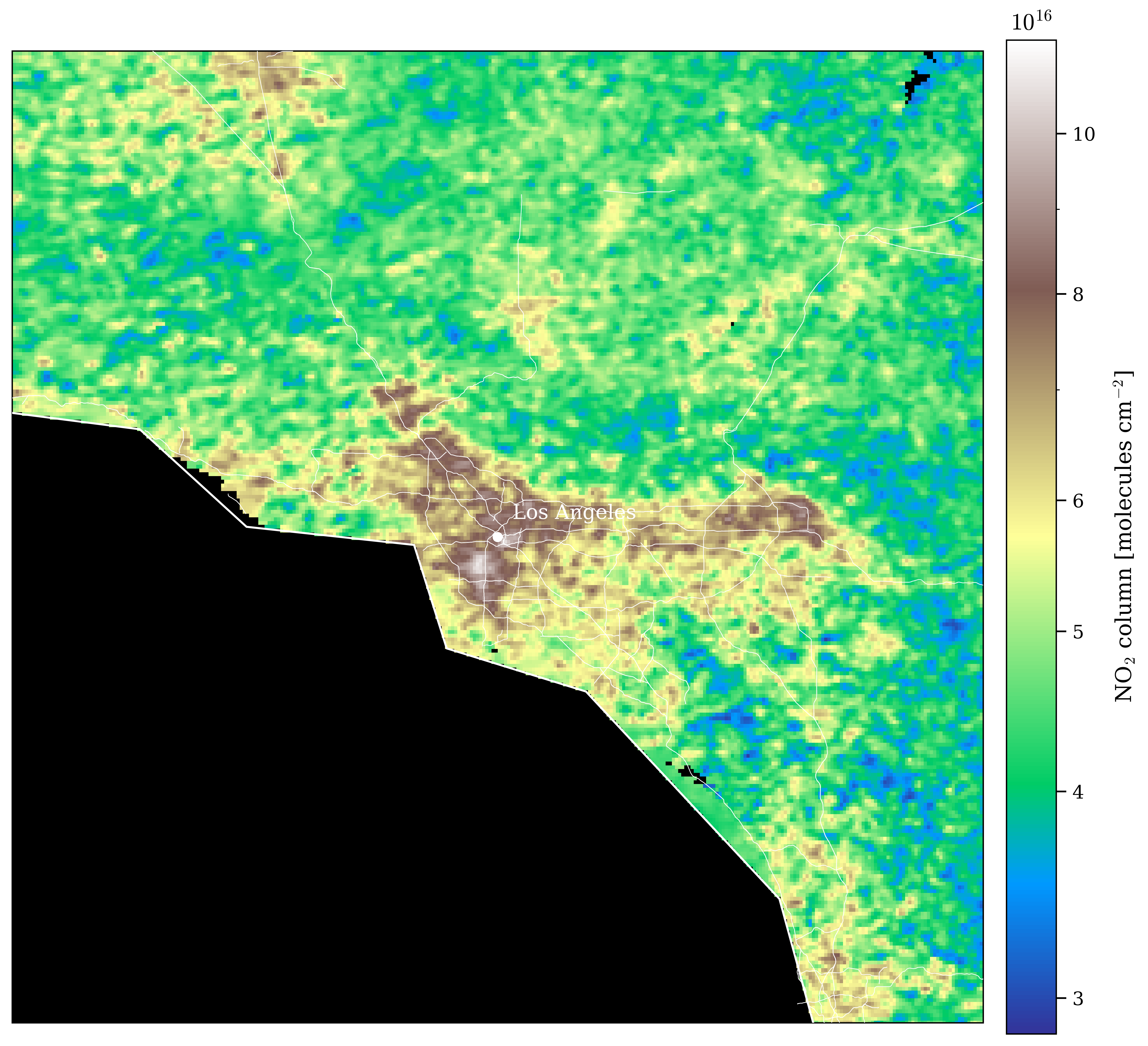
Shown here is a comparison of PACE-OCI average vertical column density of NO2 compared to TROPOMI NO2 retrievals. PACE offers up to 1.2 km spatial resolution for NO2 and O3 (not shown) once per day, can be less often due cloud cover. TROPOMI offers about 5 km spatial resolution with multiple measurements per day. Together they serve comprehensive satellite-based coverage in time and space of trace gases useful for a range of atmospheric applications.
Image Credit: Amir Ibrahim (NASA GSFC)
Why This Matters
O3 and NO2 measurements from PACE describe the average vertical column density of these trace gases through the atmosphere, offering a synoptic view complimentary to efforts such as atmospheric modeling and on-the-ground air quality monitoring stations. This provides potential, for example, to improve understanding of O₃ production chemistry by indicating areas where NO₂ is emitted and predicting where O₃ forms as a result. At larger scales, with global coverage every day and a 2,600 km swath width, OCI provides information that could improve global chemistry transport models worldwide.
The practical utility of OCI's capability to measure NO₂ and O₃ extends beyond atmospheric monitoring: it can improve the quality of other satellite data products as well. Trace gases such as NO₂ and O₃ are important geophysical parameters that must be well-characterized to accurately determine Earth’s surface properties over land and ocean. For example, ocean surface reflectance retrieval algorithms typically rely on ancillary data or climatological models to account for atmospheric absorption during the atmospheric correction process. However, having coincident measurements of NO₂ and O₃ from OCI will enable more accurate atmospheric correction and, consequently, improve retrievals of surface geophysical products. This is particularly important in complex atmospheric environments such as urban and coastal regions, where atmospheric composition can vary significantly and climatological models are often inadequate.
The PACE mission reminds us that scientific instruments often hold surprises beyond their original purpose. OCI is providing a new view of trace gases by cleverly combining data from existing satellites with cutting-edge technology and ingenuity, a prime example of how collaboration and innovation can unlock new space-based tools to serve real-world societal needs.
Resources:
- Find and download Level 2 and Level 3 NO2 and O3 Data Collections from PACE (March 2024-present) on NASA Earthdata
- Jupyter Notebook tutorial on accessing and visualizing NO2 with Python, “Exploring nitrogen dioxide (NO2) data from PACE/OCI”
- Reference: Fasnacht, Z., et al. (2025) Utilizing machine learning for high resolution NO2 total columns from PACE OCI, Env. Res. Lett., 20(7), 074052, doi: 10.1088/1748-9326/addfef